Ball Family Mississippi Collection
From the Mississippi Territory to Modern Mississippi
Understanding Mississippi
This collection documents the migration and settlement of Ball families and related families throughout the Mississippi Territory and present-day Mississippi. Explore early settlements, migration routes, land records, churches, cemeteries, military service, and family histories centered around present-day Lucedale, George County, and surrounding communities.
Understanding the movement of the Ball family into Mississippi requires understanding the geography of the early Southwest. During the opening decades of the nineteenth century, Mississippi was connected to Georgia, the Carolinas, Tennessee, Mobile, Natchez, and New Orleans by rivers, Native American trails, military roads, and a small number of developing wagon routes.
Some travelers from Tennessee and the western settlements floated down the Ohio and Mississippi Rivers toward Natchez or New Orleans. Migrants traveling west from Georgia crossed lands belonging to the Creek Nation under passports issued by the State of Georgia. Others followed portions of the Federal Road and the Three-Chopped Way, which connected Georgia and the eastern Mississippi Territory with Fort Stoddert, St. Stephens, the Pearl River country, and Natchez.
These routes formed the setting for the documented migration of several related Ball, Warren, Thomson, and Mikell families during 1809 and 1810. The surviving passports establish when certain travelers received authorization to cross Creek lands. Other details concerning their precise routes, traveling companions, and final destinations must be evaluated separately as documented evidence, historical interpretation, or family tradition.
Migration into the Mississippi Territory
In 1807, the Mississippi Territory authorized commissioners Harry Toulmin, James Caller, and Lemuel Henry to survey, mark, and open a road connecting Natchez with Fort Stoddert. The route linked the territory’s western settlements with Fort St. Stephens, Fort Claiborne, and roads leading east toward Georgia.
A public notice dated 7 December 1807 reported that ferries had been completed across the Alabama and Tombigbee Rivers and that difficult crossings had been improved. Travelers could follow the route by watching for three axe marks cut into trees. These markings gave the road its familiar name: the Three-Chopped Way.
The road passed through or near Washington, the Homochitto River, Bogue Chitto, Monticello, Winchester, Fort St. Stephens, and Fort Claiborne. It became an important early east–west route across the Mississippi Territory, connecting with roads extending toward Milledgeville, Georgia.
The Three-Chopped Way formed part of the historical setting for the migrations of related Ball, Warren, Thomson, and Mikell families during 1809 and 1810. Their individual routes must be evaluated from passports, land records, correspondence, family records, and other surviving evidence.
Source: Journal of Mississippi History, “The Three-Chopped Way,” including the map of early territorial-period roads.
Why the Ball Family Chose Mississippi
William Lee had traveled through the Gulf region between Mobile and New Orleans and understood what a special place it was. I believe he told his daughter Charlotte Lee and her husband, William Bartholomew Ball, about the fertile lands, river routes, and opportunities in the Mississippi Territory. His knowledge of the region may have influenced their decision to leave Georgia and establish their family in Mississippi.
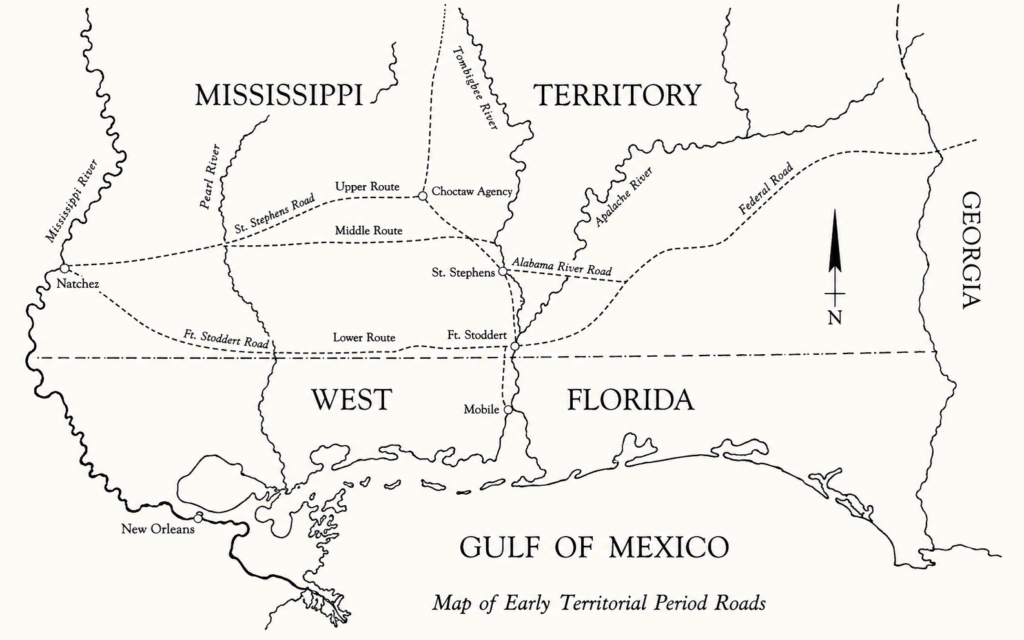
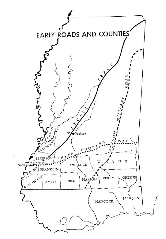
Roads, Rivers, and Ball Family Migration
Movement into the Mississippi Territory followed several distinct routes. Travelers from Tennessee and the Cumberland settlements could descend the Cumberland,Tennessee, Ohio, and Mississippi Rivers toward Natchez or New Orleans. The Natchez Trace connected the Natchez District with settlements to the north, while roads south from Natchez led toward Baton Rouge, Madisonville, Lake Pontchartrain, and New Orleans.
For migrants coming from Georgia and the Carolinas, the overland journey required crossing the Creek Nation. Georgia passports authorized named travelers and their households to pass through Creek lands. Farther west, the road opened in 1807 between Natchez and Fort Stoddert was marked by three chops or notches cut into trees and became known as the Three-Chopped Way. It connected the Natchez region with St. Stephens, Fort Stoddert, and the developing Federal Road toward Georgia.
These routes did not form one simple highway. They were a changing network of river passages, ferries, Native American paths, military roads, and wagon roads. The route selected by a family depended upon its point of departure, destination, season, transportation, and political conditions within Native lands.
Multiple Routes into Mississippi
These routes formed the setting for the documented migration of several related Ball, Warren, Thomson, and Mikell families during 1809 and 1810.
William Bartholomew Ball received a Georgia passport in 1809 authorizing travel through the Creek Nation. He remained in Richmond County until 1810 and later settled near the Pearl River.
On 5 January 1810, John Warren received a passport for himself, his wife, two children, and seven enslaved people. Fleming Tynes of Liberty County received a passport on the same date for himself, his wife, two children, and one enslaved person.
Sampson Edward Ball, son of Edward Ball, R.S., and brother of William F. Ball, received a passport dated 28 February 1810 for himself, his wife Elizabeth, five children, and thirteen enslaved people. He later established his family in the western Pearl River region, near Sandy Hook and the area later associated with Balltown.
On 19 April 1810, Captain James Mikell received a passport from Liberty County for himself, his wife Margaret Thomson Mikell, four children, and five enslaved people. Margaret was a cousin of both Sampson Edward Ball and William Bartholomew Ball.
These passport records document related households moving through Creek lands during the same period. They do not prove that every family traveled in one wagon train or followed exactly the same road. The surviving evidence instead shows a connected migration into the Mississippi Territory through several routes and stages.
The Three-Chopped Way
The Three-Chopped Way was opened in 1807 to provide an east-west connection across the Mississippi Territory. Commissioners Harry Toulmin, James Caller, and Lemuel Henry were assigned to view, mark, and open a road from Natchez toward Fort Stoddert, intersecting the Creek road east of the Pearl River. The route was identified by three notches or chops cut into trees so that travelers unfamiliar with the country could follow it safely.
From Natchez, the road passed through or near Washington, the Homochitto River country, Bogue Chitto, Monticello, Winchester, St. Stephens, Fort Claiborne, and Fort Stoddert. Farther east, connections led toward the Federal Road and Georgia. The route crossed rivers, swamps, Native lands, and sparsely settled country. Ferries, causeways, military posts, and settlements gradually made wagon travel possible.
The Three-Chopped Way was therefore not merely a local trail. It became one of the principal early connections between the eastern and western portions of the Mississippi Territory and helped make family migration, postal service, commerce, and government travel possible.
Crossing Creek Lands: The Passport Record
Travel west from Georgia required passage through Creek lands. Georgia’s surviving passport records provide direct evidence that several related households prepared for this journey during 1809 and 1810.
William Bartholomew Ball received a passport in 1809. Records indicate that he remained in Richmond County until 1810 before moving west.
On 5 January 1810, John Warren received a passport for himself, his wife, two children, and seven enslaved people. Fleming Tynes received one on the same date for himself, his wife, two children, and one enslaved person.
On 28 February 1810, Sampson Edward Ball received a passport to cross Indian lands with his wife Elizabeth, five children, and thirteen enslaved people.
On 19 April 1810, Captain James Mikell received a Liberty County passport for himself, his wife Margaret Thomson Mikell, four children, and five enslaved people. Margaret was a cousin of Sampson Edward Ball and William Bartholomew Ball.
These records establish planned movement across Creek territory. They do not prove that every household traveled together or followed exactly the same road. Family relationships and later settlement evidence nevertheless place the Ball, Warren, Thomson, and Mikell families within the same broad migration into the Mississippi Territory and Pearl River country.
Editorial note: Historical documents counted enslaved people as members of these traveling parties. They are identified here as people, not property.
A Kinship Network Moving West
The passport records reveal a network of related families preparing to move west during the same period. William Bartholomew Ball was the uncle of Sampson Edward Ball and William F. Ball, sons of Edward Ball, R.S. Margaret Thomson Mikell, wife of Captain James Mikell, was a cousin of Sampson Edward Ball. John Warren was connected through his daughter Elizabeth Warren, who married Sampson Edward Ball.
Sampson Edward Ball’s passport was dated 28 February 1810. He later authorized his brother William F. Ball to collect his share of their father Edward Ball’s estate. The surviving account describes Sampson Edward moving his family, household goods, farming tools, livestock, and enslaved laborers westward.
These relationships help explain how migrants could organize a difficult passage through Creek lands. Kinship offered information, supplies, labor, companionship, and security. The evidence supports coordinated migration, but does not prove that every household traveled together in one wagon train.
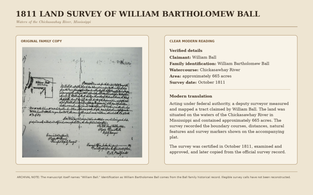
William Bartholomew Ball and Charlotte Lee
William Bartholomew Ball married Charlotte Lee in Richmond County, Georgia, on 1 January 1796. Their family later moved into the Mississippi Territory and settled in the region that became Greene and George Counties. Their younger children’s birth records place the household in Mississippi by the 1810s. William Bartholomew Ball died after 1841 and before the 1846 estate-tax entry in the Vernal community of present-day George County.
His precise route from Georgia has not been proved by a surviving travel record. A Georgia passport issued to him in 1809 documents authorization for passage through Creek lands, but does not prove that he traveled with the Mikell, Warren, or Sampson Edward Ball households.
Family tradition reported by Dr. Carroll Ball places William Bartholomew Ball and Charlotte Lee near a Three-Chopped Way ferry crossing on the Chickasawhay River. The tradition describes a stand operated by William and his son James Sampson Ball where travelers could obtain food, security, rest, and whiskey kept for medicinal or comfort purposes. The location and operation of this stand still require confirmation through land, ferry, tax, court, or travelers’ records.
The Vernal Community and the Ball Family Home
The Vernal community lay within the area later divided between Greene and George Counties. William Bartholomew Ball and Charlotte Lee established their household in this region, where the family became part of the early settlement network along the Chickasawhay River.
Family records place three of their younger children in Mississippi: Margaret Ball, born 3 January 1816; Harriet Mahalia Ball, born 22 July 1818; and Henry Augustus Ball, born 10 January 1821. These dates show that the family was established in the region by the 1810s, although each birthplace should be checked against the surviving Ball family Bible and original records.
William Bartholomew Ball remained associated with the Vernal community until his death about 1843. George County was created later, so records from his lifetime may be filed under Greene County or another earlier jurisdiction.
The Ball Stand and Chickasawhay River Crossing
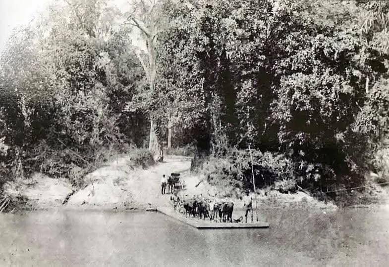
McLeod’s Ferry, Vernal Community, Greene County, Chickasawhay River, circa 1900. From the collection of the late James Dunnam housed at the Greene County Museum & Historical Society, Leakesville.
Sources and Further Research
Principal sources consulted for this page include:
• “The Three-Chopped Way,” Journal of Mississippi History. The article and its map of early territorial roads are preserved in the BFA Digital Archive.
• Dunbar Rowland, ed., Mississippi: Comprising Sketches of Counties, Towns, Events, Institutions, and Persons, vol. 2 (1907), pp. 566–571.
• Georgia passport records documenting travel across Creek lands, including passports issued to Sampson Edward Ball, Captain James Mikell, and John Warren in 1810.
• Ball family Bible records and related family research concerning William Bartholomew Ball, Charlotte Lee, and their descendants.
• Family tradition preserved by Dr. Carroll Ball concerning the Ball stand and Chickasawhay River crossing. This tradition requires further confirmation from land, ferry, court, tax, and travelers’ records.
Research Note
Documented records establish the territorial routes, the 1807 opening of the Three-Chopped Way, and Creek-land passports issued to members of the related Ball, Mikell, Thomson, and Warren families. The exact route taken by each household, the location of William Bartholomew Ball’s home, and the operation of a stand near the Chickasawhay River crossing remain subjects for further research. Family tradition is identified as tradition and is not presented as proven fact.
Genealogical Research Collections
Explore genealogy, historical records, military service, maps, and more than three centuries of Ball family history.


Featured Collections
Explore some of the Association’s most significant historical collections, featuring Revolutionary War service, colonial South Carolina, and generations of preserved family research.
Revolutionary War Collection
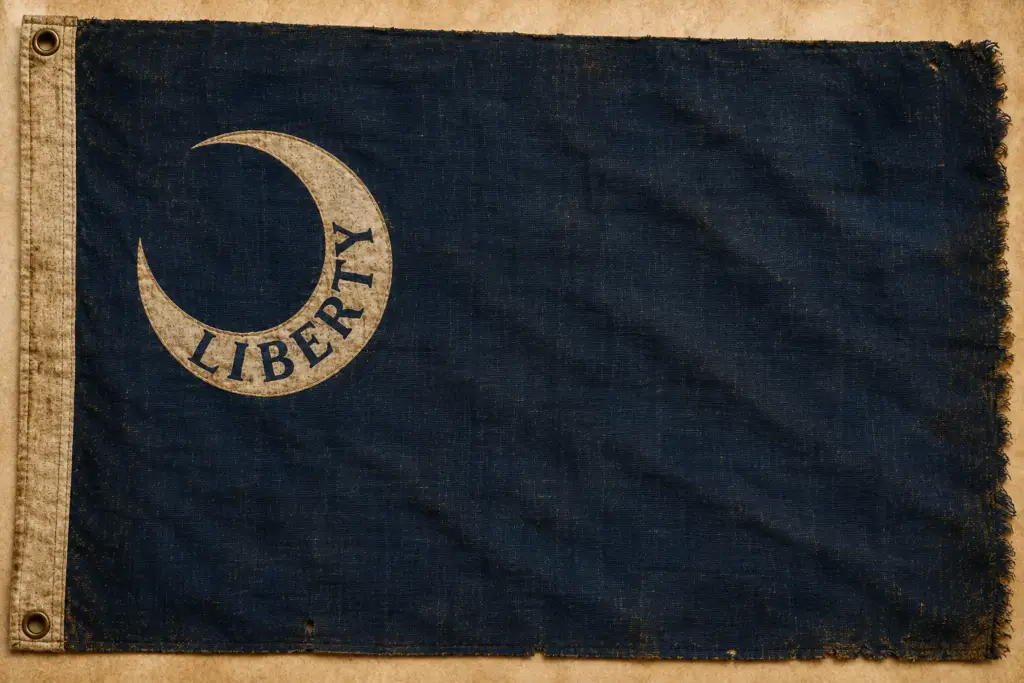
Discover the Ball family’s military service during the American Revolution through militia rolls, pension files, service records, battle histories, maps, and original research documenting the sacrifices and achievements of generations of Ball descendants.
Colonial South Carolina Collection
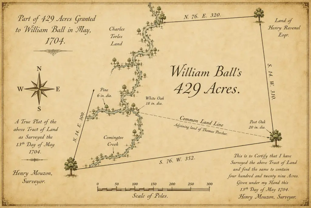
Explore original colonial land grants, plats, deeds, parish registers, probate records, and early settlement documents documenting the Ball family’s first generations in colonial South Carolina.
Museum Collection No. 1704-01
Original survey plat of William Ball’s
429-acre land grant.
Surveyed 13 May 1704 by Henry Mouzon.
Ball Family Genealogy
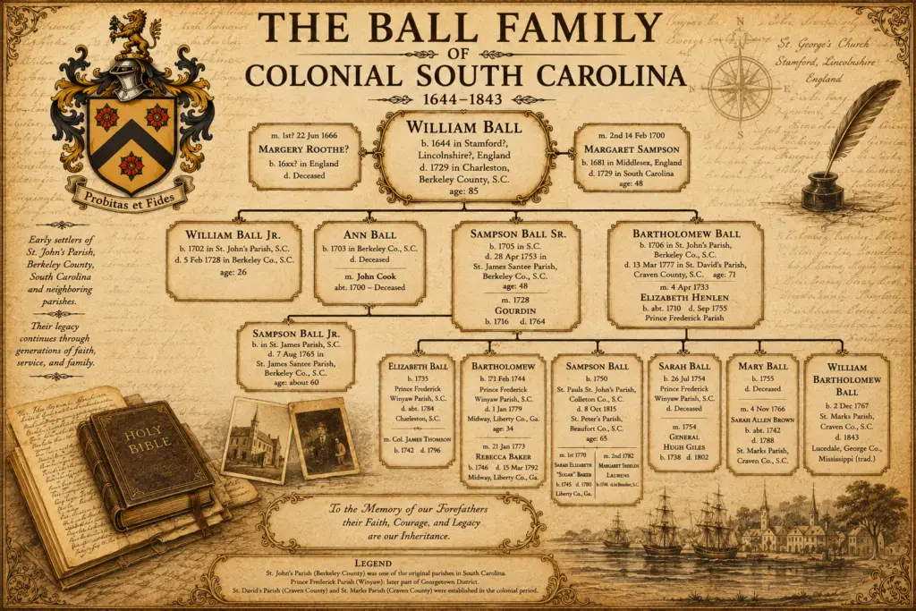
Search family lines, descendants, photographs, Bible records, cemetery surveys, and generations of documented Ball family genealogy.
Museum Collection No. F-1704-01
Founding generations of the Ball family in Colonial South Carolina
From William Ball (1644–1729) through the third generation
Historical Documents
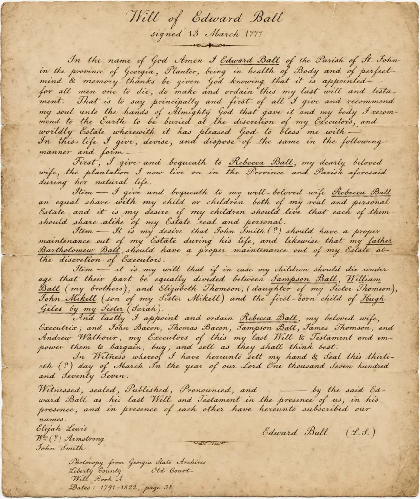
Browse original wills, letters, church records, manuscripts, photographs, newspapers, and rare historical publications preserved by the Ball Family Association.
Museum Collection No. 1777-03
Last Will and Testament of Lt. Edward Ball
Signed 13 March 1777 • Georgia State Archives
Maps & Land Grants
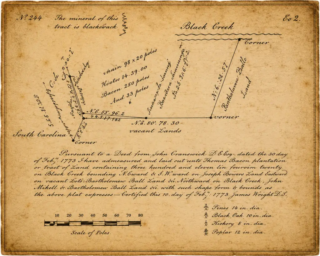
Explore historic maps, plats, surveys, property records, and land grants that document the movement and settlement of Ball families across America.
Museum Collection No. 1773-02
Black Creek survey plat showing Thomas Bacon’s plantation and adjoining Ball family lands Surveyed 10 February 1773 by James Wright, D.S.