
1682
Proprietary Counties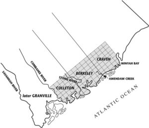
IN THE BEGINNING:
From the establishment of a colony on the Ashley River in 1671 until roughly 1710, South Carolina was part of “Carolina,” which embraced both modern North and South Carolina. South Carolina was recognized as a royal colony in 1729.
In 1682–83, the first three counties were established by the Lords Proprietors for the purposes of local government, administration of justice, granting of land, and the election of representatives to the legislative assembly: Berkeley, Colleton, and Craven, with a fourth, Granville, established somewhat later.
All were discontinued in 1769, and the present Berkeley County is not the original. These old county names are found on early documents and can cause confusion when searching for records.
Of primary importance to the researcher is the fact that records predating 1785 were all filed in Charleston, irrespective of residence in these old “royal” counties. These early documents will be found at the South Carolina Department of Archives and History in Columbia, South Carolina.
OLD BERKELEY COUNTY
1683–1769 — Created 1683; discontinued 1769
One of the original “counties” created by the Lords Proprietors for administrative purposes, Berkeley County centered around Charleston and extended from the Stono River on the south to Sewee Creek—modern Awendaw Creek—on the north.
See the 1682 map for the modern counties represented in this area. All records for this area were filed in Charleston. This is not modern Berkeley County.
OLD COLLETON COUNTY
1683–1769 — Created 1683; discontinued 1769
One of the original “counties” created by the Lords Proprietors for administrative purposes, Colleton extended from Sewee Creek—modern Awendaw Creek—on the north to the Combahee River.
See the 1682 map for the modern counties represented in this area. All records for this area were filed in Charleston.
OLD CRAVEN COUNTY
1683–1769 — Created 1683; discontinued 1769
One of the original “counties” created by the Lords Proprietors for administrative purposes. See the 1682 map for the modern counties represented in this large area. All records for this area were filed in Charleston.
OLD GRANVILLE COUNTY
1683–1769 — Created 1683; discontinued 1769
One of the original “counties” created by the Lords Proprietors for administrative purposes, Granville extended from the Combahee River in the north to the Savannah River in the south.
See the 1682 map for the modern counties represented in this area. All records for this area were filed in Charleston.
The area known as Granville County became Beaufort District in 1769.
1769
Seven Judicial Districts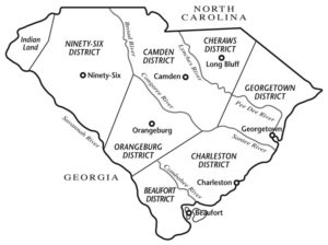
The royal “counties” had completely disappeared. The names Berkeley, Colleton, Craven, and Granville were not used as district names.
1800–1814
Districts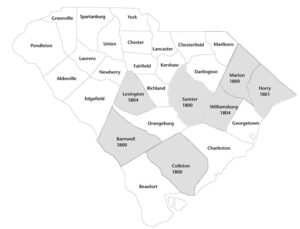
In 1800, most counties were formed into districts. Georgetown yielded Horry District in 1801 and Williamsburg District in 1804. Lexington District was formed from Orangeburg with roughly the same territory as the former county.
Parishes of the Anglican Church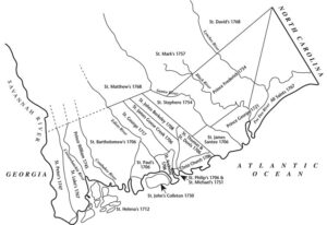
Throughout the colonial period, South Carolina’s small population and limited legal needs kept most government, recordkeeping, and judicial activity in Charleston. Parishes of the established Anglican Church served as election districts, while courts with jurisdiction over the entire colony sat in Charleston.
Maps and historical boundary information: South Carolina Department of Archives and History, “Maps Tracing the Formation of Counties in South Carolina.”